


A NEW GENERATION IN ENGINEERING
Located in Southern California, Projection Engineering is a new generation engineering service organization offering solutions and expertise in land development through GIS consulting, digital research, and field reconnaissance. We provide exceptional, professional engineering services with recognizable quality in the land development industry. Extensive knowledge in cutting edge technology allows us to meet the goals and objectives set forth with unbeatable results.
OUR FOCUS
Our focus is on good client relations, continual communication, and honest and accurate representations of project progress. We want your experience with Projection Engineering to be positive, open, and user friendly. Meeting our client's needs is the most important aspect of making a project successful, for both us, and the client.

OUR PROFESSIONAL SERVICES
Offering Solutions that Make a Difference

ENTITLEMENT/PRELIMINARY ENGINEERING SERVICES
Projection Engineering provides full civil engineering deliverables for entitlement phase and preliminary engineering design. This includes feasibility studies, grading analysis, tentative maps, and exhibit preparation for agency submittal.
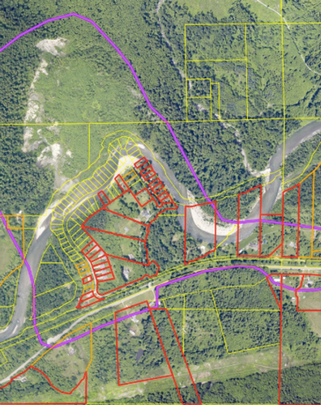
GPS/GIS BASE MAP CREATION
These services include the preparation and compilation of digital base maps including GIS data search, field reconnaissance, and route documentation.


FINAL ENGINEERING SERVICES
Once you project is entitled, or conditionally approved, Projection Engineering provides full civil engineering deliverables for agency submittal including rough/precise grading plans, erosion control plans, storm water hydrology and hydraulic calculations, storm water design and technical reports, water and sewer improvement plans, and street improvement plans.
PROJECTS
What We’ve Accomplished

POWER/ENERGY PROJECTS
Hoffman Summit Wind Project - Tehachapi Mountains, California
Pine Tree Wind Project - Tehachapi Mountains, California
Langford Wind Project - Texas
Wind Project Feasibility Analysis - Mojave Desert, California
French Valley Power Plant - Winchester, California

INDUSTRIAL/DISTRIBUTION PROJECTS
Rubbermaid Distribution Center, Buildings 13A, 1 and 15A & 15B - Victorville, California
Space Center Industrial Project

CIVIL/PUBLIC WORKS PROJECTS
Casa de Amparo - Twin Oaks, California
California State University San Marcos - San Marcos, California

RETAIL/COMMERCIAL PROJECTS
Quarry Creek - Oceanside, California
Honda Car Dealership & Nissan Car Dealership - Victorville, California

SUBDIVISIONS/SINGLE FAMILY RESIDENTIAL PROJECTS
4S Ranch - San Diego, California

MULTI-FAMILY RESIDENTIAL PROJECTS
La Costa Condominiums - La Costa, California
Winchester Ranch - Winchester, California
Bella Sol - Winchester, California
CREDENTIALS
What Sets Us Apart
CIVIL ENGINEERING DESIGN
We handle all aspects of engineering design including access roads, slopes, swales, brow ditches, pads, desilting basin design, riprap sizing, and multiple types of free standing and retaining walls. We utilize Land Desktop to create terrain models from elevated AutoCAD entities and contours, which are then used to perform elevation tracks, earthwork analysis, cut/fill maps, and 3D model rendering. Our capabilities extend to analyzing soils reports to understand slope stability, buttressing, and sub-drains. We design a multitude of improvements including roadway design, parking lot design, sewer, water, and storm drain.

GIS / GEOSPATIAL ANALYSIS
We are experts in online spatial data mining and file type conversion from various formats to a usable end product (3D topographical information, infrastructure, census etc.). We manipulate raw spatial data toward the compilation of aesthetically pleasing base maps and project exhibits for all types of uses. We gather field information with GPS units in order to gain more accurate project information and create base map compilation and project exhibits. We have a high understanding of coordinate system geometry and coordinate geometry manipulation (System, Datum, Projection, Zone, Units).

MAPPING & SURVEYING
We are experts in mapping and survey services. We are heavily involved in project acquisition and preliminary research, both at city and county offices. We have meticulously created record boundaries for projects to tie in with panels for aerial topography. We handle title reports, title officers, and plotted easements, and we curate final maps and parcel maps under supervision of a licensed surveyor. We are proficient in Plats, Legal Descriptions, Traverses, and ALTA's. We create plats for easements and dedications, write legal descriptions to describe easements and dedications, use AutoCAD parcels menu to print traverses, and curate ALTA documents from title reports, maps, and exception documents.

CONTACT US
1230 Cedar St, Ramona, CA 92065, USA
Mobile: (760) 443-6504